After our whirlwind city tour, we were good and ready for some outdoor adventures again. And what better place to do so than Norway, arguably one of the top hiking destinations in western Europe. Before we arrived, we had put together a rough itinerary of where we wanted to go and which hikes we wanted to do. Unfortunately, the closer we got to Norway, the worse the weather forecast looked. Although weather can change, it was looking pretty grim, and we were feeling rather disheartened. We’d spent a lot of time and money to get there, and we wanted to enjoy the experience as much as possible. So, with the flexibility afforded to us by living in a van, we threw out the initial plan and decided instead to follow the sun! We kept our eyes on the forecast, chose a few activities we wanted to do in the areas that looked sunny, and ended up having a fantastic time - and (mostly) blue skies!
Driving in Norway can be summarized in two words: tunnels and tolls. The tolls can be quite high (we saw up to 90NOK or around 9€ for a single toll while driving), and we saw both automatic toll cameras as well as a few manual toll booths (mostly in rural areas). Apparently the toll system can take up to three months to process your invoice, so we are still blissfully unaware of how much we racked up! Even more numerous than the tolls are the tunnels. It seems Norway’s answer to mountainous terrain is to go straight through! We drove through a variety of tunnels, from well-lit with finished walls to poorly lit (requiring high beams when there was no oncoming traffic!) and rough rocky sides. The most impressive part, though, was the length - we drove through a 24.5km-long tunnel! Every 6km or so there was a large cavern lit up impressively with blue lights. I suppose this was a form of keeping drivers entertained so they don’t fall asleep. I heard there are some long tunnels in Norway which feature roundabouts along the way to elicit the same effect, but we didn’t encounter any.
The other surprising thing about the tunnels was the excellent 4G cell signal throughout! This was a theme throughout Norway - we’d drive into seemingly remote areas, but there would still be signs of civilization: strong 4G, street lights along some sections of the road, and small holiday cabins scattered around. It was in one of these sorts of areas that we embarked on our biggest planned hike: Ranastøngji.
From the ski town of Hemsedal we drove about 18km to the trailhead along a rural road. When we got out of the van on arrival, it was markedly colder than Hemsedal, due to both the elevation and the wind. We started at around 1150 metres above sea level and would climb to 1900, so we expected to see temperatures as low as 1C. The great thing about the camper is that we could pop back in and put a few more layers on before we got started!
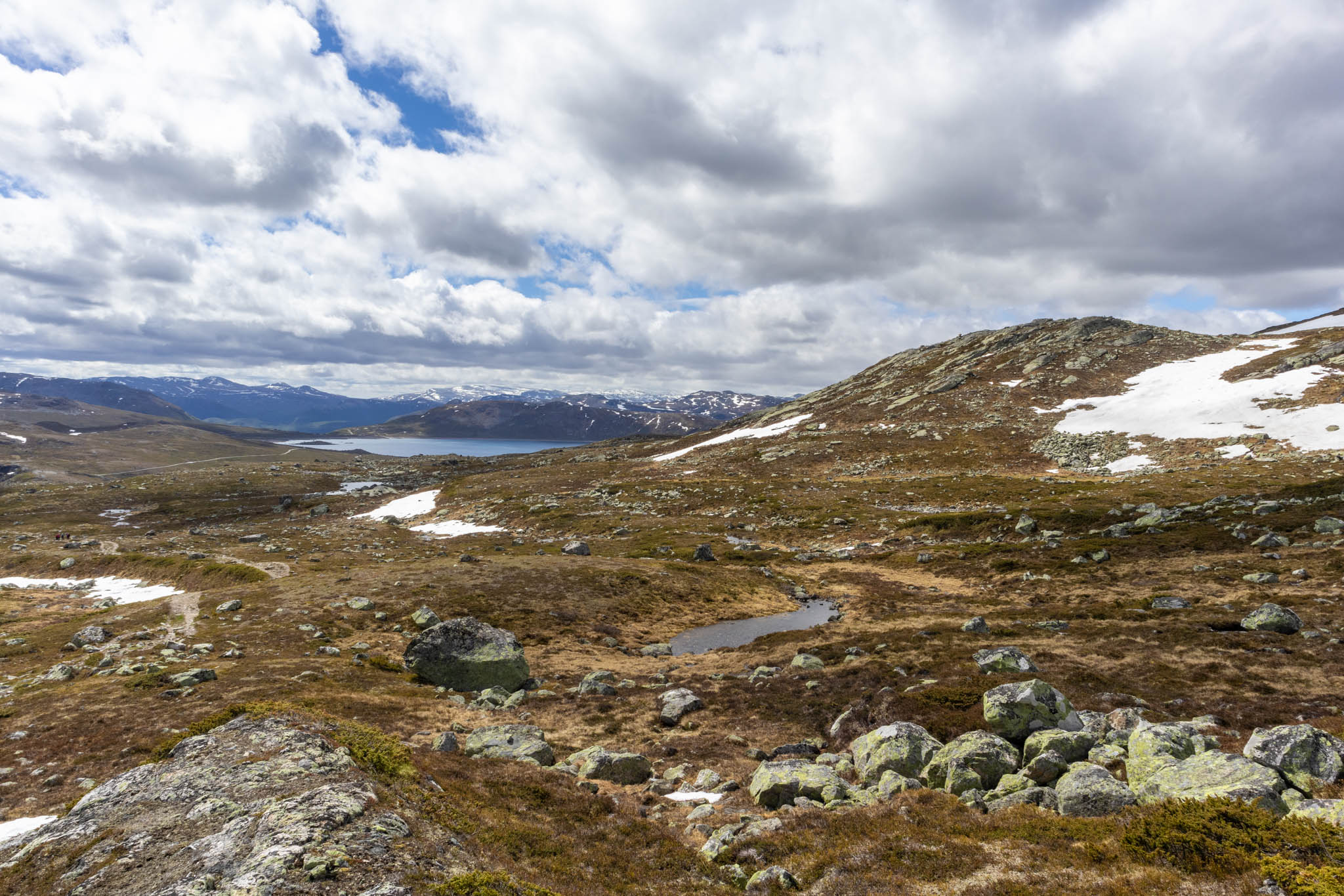
The weather was mostly cloudy when we started, but the sun began to poke through as we began the moderate ascent. There was only one other group behind us as we got underway, although we did see two other cars in the parking area. The first kilometer or two passed uneventfully. We enjoyed the fresh air and the chance to really stretch our legs for the first time in days. The views continued to improve as we climbed higher over the lake. I discovered pretty quickly that I hadn’t eaten enough before leaving, though, so we stopped for an early lunch and took in the view (pictured at the top of this post).
Things took a turn when we were approximately one third of the way to the top, distance-wise. We’d been climbing alongside a river, and from the map we knew that we’d need to cross at some point. Earlier in the day, I had scrolled through the AllTrails reviews of the hike and noticed a comment about a river crossing being tricky in the spring, but hadn’t thought much of it (and couldn’t do much about it regardless). They weren’t kidding - as we walked back and forth along the bank, trying to find a suitable place to cross, we realized there really wasn’t one. Or at least not one that would keep our boots relatively dry! I definitely considered turning back at this point, because the water was pretty high and flowing quickly, but I figured we may as well give it a shot first before calling it a day. So we took off our boots and socks, rolled up our trousers and braced ourselves for the freezing-cold water (snowmelt from the top of the mountain). Jacob went first, as he had visualized a particular route across. Based on his reaction to the water temperature, I was not keen on taking my turn. And boy, was the water cold! My feet hurt from the cold, and I was pretty scared a few times when I had trouble finding my footing on the slippery rocks with the water rushing by. But I made it across safely, and felt very accomplished in doing so! Putting my boots back on felt so good, and we quickly got underway again to warm up.
 Jacob making the river crossing - it looks much easier here than in reality!
After we left the river, the weather continued to improve, and we enjoyed ourselves immensely as the trail continued to get steeper. We also realized we were now the only ones on the trail, as the other groups seemed to have turned off at or before the river crossing. The wind also picked up, so I was glad we brought a few extra layers to keep warm. As we got higher up, there were also large snow patches we needed to cross. The snow was obviously not very good, so we ended up sinking in quite a bit as we walked, which made for some slow going. Thankfully we’d worn gaiters, so we stayed pretty dry. This was also where the boulder fields began, which I generally find quite challenging due to my lack of depth perception. We continued to make our ascent, but as we alternated between boulder fields and snow patches it started to feel more like a grind. Thankfully, every time we looked behind us, we were rewarded with a stunning view.
 The view from the upper part of the hike
We reached the summit after 7.5km of hiking and 840m of elevation gain. The wind at the summit was incredibly high! Thankfully there was a large cairn we could hide behind to catch our breath. We celebrated with some Jelly Babies and attempted to sign the log book, but unfortunately the box was empty. We were under the impression that this wasn’t a particularly popular hike, which suited us just fine. We didn’t linger long on the summit due to the wind, but instead got started on the descent.
 Ranastøngji summit at 1900m above sea level
As we made our way downwards, the weather got progressively worse. We’d noticed some light snow falling on our way up, but the snow got heavier and pelleted our faces in the headwind. It wasn’t particularly pleasant, but because it was so windy the clouds were shifting quickly and it was lovely to watch them blow over the lake. Things continued to clear up as we descended and the last quarter or so of the hike was sunny (although snowflakes still fell around us!). This didn’t do much to make the river crossing any more enjoyable the second time around, however!
 Snowy patches and boulder fields comprised the upper part of the hike
Usually I am pretty done with a hike by the time we get to the last part of the descent, but that was not the case here. The quality of the light from the early evening sun was so warm and golden, and the scenery around us so beautiful, that I slowed right down and tried to commit the moment to memory. That feeling of being by ourselves, out in the wilderness, surrounded by imposing mountains and warmed by the glow of the sun is one of my favourite feelings, and I value each opportunity to pursue it.
Overall this hike was one of my favourites that we’ve done, alongside the Iceline trail in the Rockies. I felt happy and strong during the hike, the scenery was amazing, and the river crossing was an exciting challenge. Norway did not disappoint!
 We stopped for a snack of brunost (Norwegian brown cheese) on our way down